Where does MH370 go?
Malaysia Airlines Flight 370 (MH370) disappeared on 8 March 2014 while flying from Kuala Lumpur International
Airport, Malaysia, to Beijing Capital International Airport in China. The
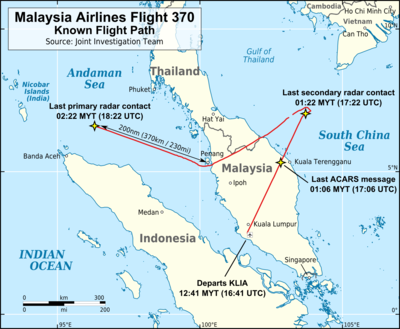
aircraft last made voice contact with air traffic control at 01:19 MYT, 8 March
when it was over the South China Sea, less than an hour
after takeoff. It disappeared from air traffic controllers' radar screens at 01:22
MYT. Malaysian military radar continued to track the aircraft as it deviated
westwards from its planned flight path and crossed the Malay Peninsula. It left
the range of Malaysian military radar at 02:22 while over the Andaman Sea, 200
nautical miles (370 km) north-west of Penang in north-western Malaysia. The
aircraft, a Boeing 777-200ER, was carrying 12 Malaysian crew members and 227
passengers from 15 nations.
On 29 July 2015, aircraft debris was found on a beach in
Saint-André, on Réunion. It was transported to Toulouse, for examination. On 2 August, Malaysian officials confirmed that the object
was a flaperon from a Boeing 777 aircraft and that the verification was made. Three days later, the Prime Minister of
Malaysia announced that the discovered flaperon was confirmed to be from Flight
370; French
officials announced that serial numbers found on the flaperon link it
"with certainty" to Flight 370.
As we know that, there is no confirmed news received from the aircraft. It is impossible for the flight to land on anywhere. Also, aircraft debris was found and confirmed to be part of the missing aircraft. Since the officials concluded that the airliner's last position before it disappeared was in the Southern Indian Ocean. As there were no places there where it could have landed, So it is very likely that the plane have crashed into the sea.

I think your comments are quite making sense, writing in quite a fluent way. May be you can add some videos, images, references to show the evidence and increase the attractiveness of the post.
回覆刪除